
ATASCOSA
COUNTY HISTORY
TXGENWEB
TXGENWEB

| |
ATASCOSA
COUNTY HISTORY TXGENWEB |
|
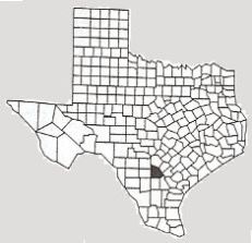
Atascosa County takes its name from its main water course, the Atascosa River. The river traverses the
county generally from northwest to southeast. “Atascosa” is a Spanish word
meaning “boggy,” and may refer to miry areas found intermittently along the
river’s banks.
The county seat is Jourdanton. Marriage, land, and probate records of Atascosa County are intact from the beginning of the county in 1856 to the present time. The County Clerk’s office maintains these records.
The largest towns in Atascosa County are Pleasanton, Jourdanton, and Poteet. Other towns include Lytle, Charlotte, Christine, Campbellton, Leming, and Peggy. Unincorporated population areas include Verdi, McCoy, Leal, Fashing, Kyote, Rossville, and Espey. Of these unincorporated areas, only McCoy has its own post office. Names of other old communities can be seen in the names of cemeteries, such as Shiloh and Amphion.
The earliest inhabitants were Native Americans. The earlier Coahuiltecan tribes were replaced by Plains Tribes, such as Comanche, Apache, and Lipan. Spaniards probably first came through the area in the 1600s. Mexican families who came to stay in the 1700s mainly engaged in ranching. “Anglos” began filtering in during the Republic of Texas days, with their families finally beginning to arrive and settle in the early 1850s.
Atascosa County was formed from the Bexar District and organized in 1856. The first county seat was at Navatasco, located on land donated by Jose Antonio Navarro, for whom Navarro County would soon be named. Navarro had large land holdings in what became Atascosa County, and was prominent throughout its early history. A story I heard as a child said that the name “Navatasco” was created by combining the first syllables of “Navarro” with the beginning syllables of “Atascosa.”
Navatasco remained the county seat for a very short time. The location was plagued by “Indian” troubles, which probably interfered with conducting county business. When the new town of Pleasanton was organized in 1858, the county seat was moved there. Pleasanton remained the county seat until 1910, when the county records were moved to a new court house in Jourdanton.
The county boundaries have remained almost as first drawn. The only changes occurred early on, in 1858, when a portion to the west was taken for Frio County, and a portion to the south was taken for McMullen County. Each of these actions created a straight-line border between the respective counties and Atascosa County.
The early economy was based on farming and ranching. Agriculture is still important in the county, today, but the economy has also benefitted from the mining of oil, natural gas, silica sand, and coal.
This page content Copyright © 2008 TXGenWeb; compiled by Marcy Porter.