|
Historical Sites
|
Alsatians of Texas
(Houston Square, Castroville)
In 1842, Empresario Henry Castro brought his first
colonists to Texas to settle land west of the Medina River. Most of
the immigrants were from the Rhine River area of Europe. Many
claimed the province of Alsace, on the border of France and Germany,
as their homeland. The Alsatian colonists brought with them their
combined French and German heritage, which has left a distinctive
mark on this area of the state. In 1844, Castro laid out a townsite,
which the settlers chose to name Castroville. It became the center
of Alsatian culture in Texas. The houses, European in style, are
primarily single-story dwellings of cut limestone, mortared with
adobe, and white-washed. Over the years, farming has been the major
occupation of people in the area, as it was in Alsace. The Alsatian
immigrants and their descendants have made a distinct impression on
area politics, holiday customs, cusine, and religion. Winemaking,
using grapes grown along the Medina River, is another early
tradition that has continued over the years. The history of
Alsatians in Texas is a reflection of ethnic and cultural diversity
in the state's rich heritage. (Marker - 1985) |
|
Arcadius Steinle House
(1416 Florella St., Castroville)
A native of Hettingen, Prussia, and a
mason by trade, Arcadius Steinle emigrated to the U.S. in 1844 and
moved to Castroville the next year. In 1847, he wed Marie Ann Dreyer
and began construction of this home, where they reared six children.
Arcadius died in 1858, and in 1858 Marie wed his brother, Franz. To
the union were born five more children. The home later passed to son
Henry Steinle, and it remained in the family until 1946. Built in
phases to accommodate the growing family, it is a vernacular,
side-gable house of stucco over rubble stone and a rear ell of
timber frame and stone. Features include a central entry flanked by
paired windows. (Recorded Texas Historic Landmark, 1962) |
|
Battle of the Arroyo
Hondo
(FM462, 6.5 miles north of Hondo)
In 1842 the Mexican Army launched
three invasions into Texas to reclaim territory lost during the
Texas Revolution. Col. Rafael Vasquez's Army briefly occupied San
Antonio in March, and in July Texans fought with Col. Antonio
Canales' forces near San Patricio. When Gen. Adrian Woll's Mexican
forces advanced through South Texas and captured San Antonio on
September 11, Texan volunteers gathered for battle. More than 200
men under the command of Matthew Caldwell assembled at Salado Creek
six miles east of the city, where on September 18 they fought with
the Mexicn Cavalry. With losses on both sides, the Mexicans returned
briefly to San Antonio before beginning their march toward the
border. Additional Texan forces marshaled to meet Woll's Army, and
on September 21 another battle occurred at Hondo Creek (Arroyo
Hondo) near this site. Although Texan and Mexican accounts of the
engagement varied considerably, reliable sources indicate that the
Texans, plagued by dissension and a lack of clear leadership, failed
in their attempt to rout the Mexican forces. The Mexicans returned
home and the Texas government, in response to the 1842 invasions,
mounted the ill-fated Somervell Expedition later that year.
(Marker - 1992) |
|
Berger House
(1003 Sixteenth St., Hondo)
From Application for Texas Historical
Building Medallion: Brick, partial two-story, inner walls also solid
brick, hand-carved staircase, other hand-carved interior features,
tongue-and-grooved wood ceilings. (Marker - 1964) |
|
Bethlehem Lutheran Church
(FM2676, Quihi, 8 miles NE of Hondo)
The Rev. Christian Oefinger, serving
as pastor of the Castroville Lutheran Church, led in founding this
congregation in March 1852. The first church building was dedicated
in 1854, coincidental with a synod convention held in Castroville.
Bethlehem Lutheran Church hosted synod meetings in 1869, 1875, and
1894. The present brick structure, dedicated in 1914, was built
largely by parishioners. St. John's Lutheran Church of New Fountain,
founded in the late 1850s by the Rev. A. Kitterer and served by
Bethlehem's pastor, merged with this congregation in 1949. (Marker - 1977) |
|
Castroville Historic
District
(Roughly
bounded by Medina River, SR 471, Gime, Houston, and Constantinople)
Castroville is a peaceful Alsatian community
spread out on either side of the highway as it crosses the Medina
River twenty-five miles west of San Antonio, Texas. Ninety-six
buildings in the community of Castroville, Texas have been surveyed.
With only a few exceptions they are all of a type unique to this
county which was settled in the main by peoples from Alsace. The
surveyed buildings were constructed from 1844 to the 1880 and
maintain a consistent character throughout this period. The
buildings tend to be scattered evenly throughout the town and
dominate the character of the community.
The earliest houses were usually small two room
and loft stuccoed limestone structures with red tin or less
frequently cyprus shingle roofs. The kitchen was either attached
under a shed roof at the rear, giving the building a salt box
silhouette, or in a separate nearby structure. The attached kitchen
could stretch across the back or only take up one side of the back
leaving an inset porch in the remainder of the space. Some of the
smaller houses have only a single chimney, many have one at each
gable end thus warming both rooms and the loft. With the attached
kitchen there is an additional kitchen chimney toward the rear.
Most of the houses were set very close to the
fronts of the lots. Frequently there is a gallery or wide porch
either inset under an extension of the roof line or in the one and a
half story houses attached with a separate roof.
Ornament, even where Victorian brackets are found,
is very simple and somewhat austere. Frequently the exposed
limestone smokehouses still exist. The interiors are whitewashed
with occasionally extant whitewashed stretched canvas ceilings.
Cedar and cyprus were the most common woods used for beams. The
doors when paneled have removable wood panels over glass panes.
The very thick limestone walls (generally 18")
permit the insertion of loft windows directly beneath some of the
chimney as the flues can be angled inside the walls. These walls
keep the houses cool in the day and warm at night. Basements are not
uncommon. A few log structures remain.
As time has passed many of the houses have had
additions but on the whole these additions have maintained the scale
and character of the original buildings.
The churches, commercial buildings surveyed, and
the courthouse, although distinct and not always typical of the
residential prototype, maintain the same mood and handling of
proportions that is referred to as Alsatian.
Castroville's significance lies in its retention
of the physical appearance and quality of a colony of the 1840's
with ethnic unity, and simple stuccoed stone buildings,
architecturally distinct from most of the rest of Texas and the
United States. Henry Castro (1786-1864) was French by birth, Jewish,
well-to-do, and the impresario of the colony. From 1827 to 1840
Castro was back and forth between America and France with business
relationships in both countries. In 1842 he began his role as an
impresario under the Republic of Texas. Twenty-seven boat loads of
colonists, principally from the Rhine Valley, were brought by Castro
to the Republic of Texas during the next two years to colonize a
remote, exposed, and inhospitable tract of land on the frontier.
There were considerable legal difficulties and inconveniences and
many of the immigrants broke their ties with the colony and settled
elsewhere but by 1847 "seven hundred inhabitants live in seventy
houses. Thirty-four are being built. There are four stores, stocked
with dry goods, groceries, household furniture, implements, and
tools." The town has a distinct Alsatian character that has been
preserved, as the community was bypassed by the railroad and
industry. The buildings are generously spaced, uncrowded, and small
in scale and additions and what new buildings have been added have
retained the harmony of the original town.
Lawyer, Ruth C. The Story of Castroville.
(Castroville, Garden Club of Castroville, 1968) p.7. Quote taken
from The Galveston News, 1847.
BIBLIOGRAPHY ON FILE IN THE NATIONAL REGISTER
|
|
City Hotel
(11280 Castro Boulevard, La Coste)
Built in 1912 by Alsatian immigrant
and prominent local developer Emil Schmidt, the City Hotel offered
public lodging previously unavailable to visitors to La Coste. Its
proximity to the railroad depot made it an ideal location to offer
food and lodging to the growing number of visitors and business
people involved in sales, expansion of the railroad, and the
building of a dam in northeastern Medina County. The elegantly
furnished rooms, verandas, and restaurant and ready clientele
combined to make the hotel and restaurant an immediate success. Gus
and Maggie (Ma) Keller bought the property in 1928 during the
National prohibition against the sale of alcoholic beverages. They
nevertheless ran a saloon in the hotel known as "Kellers Place"
which according to local tradition allowed patrons to gamble and
drink in a back room, an activity which because of timely telephone
calls avoided police detection. Maggie, who managed the saloon for
almost four decades, became the subject of local legend. One of the
saloon's most prominent features was the large number of bottle caps
which covered its walls and ceiling. The hotel is a local landmark
recognized by generations of people traveling through or visiting La
Coste. (Marker - 1994) |
|
Cordier-Tschirhart-Seal
House
(Intersection of Paris & Isabella Sts., Castroville)
Jean Baptiste Cordier (1804-1881)
built this Alsatian pioneer dwelling after migrating to Texas in
1844. The native limestone structure had three downstairs rooms and
an attic. Cordier sold the cottage in 1847 to blacksmith Stephan Ahr
(1821-1903) and shoemaker Jacob Biry (1810-1867), whose families
occupied it together. In 1906 the house was purchased by Eugenia
Beck (Mrs. Sebastian) Tschirhart (1861-1938). It was restored by her
descendants, Mr. and Mrs. Adrian L. Seal. (Recorded Texas Historic
Landmark, 1976) |
|
Cow Camp Massacre on
Hondo Creek
(FM462 North @ county line, about 19.5 miles north of
Hondo)
During the mid-1800s the Texas Hill
Country was the site of many hostile encounters, some deadly,
between pioneer immigrants whose permanent settlements ran counter
to area Native Americans accustomed to unrestrained hunting and
gathering. One such encounter occurred near this site on January 27,
1866. Three young men from the area, August Rothe, age 19, George
Miller, age 16, and Hubert Weynand, age 12, left their homes near
D'Hanis to recover stray livestock, an important task for area
farmers and ranchers. They set up camp on Hondo Creek and began the
"cow hunt." On the morning of the third day Rothe and Weynand were
returning to camp when suddenly Miller appeared running toward them
with eight Indians in pursuit. Unable to untie their horses in time
to escape on horseback, both Rothe and Miller ran for their lives up
a hill; Weynand attempted his escape on horseback. The encounter
resulted in Miller's death, Weynand's capture, and Rothe's heroic
escape. Weynand was never seen nor heard from again. A scouting
party later found Miller's mutilated body but were unable to
apprehend the attackers. Contemporary author A.J. Sowell wrote of
these events in his book, "Early Settlers and Indian Fighters of
Southwest Texas." (Marker - 1994) |
|
De Montel, Charles House
(northwest of Castroville)
The Charles de Montel house, located approximately
one and one-half miles northwest of Castroville Texas on 110 acres
of farm land adjacent to the Medina River, is an excellent example
of Greek Revival vernacular architecture in rural Texas. This style
is unique in an area outstanding for its excellent examples of
Alsatian buildings, somewhat more typical of their medieval
antecedents. An important figure in the area's history, Mr. de
Montel and a builder named Schott erected this stuccoed limestone
rubble house a few hundred yards west of the Medina River between
1848 and 1850. A large, one story "L" shaped building, the house was
constructed by portions in the years following Mr. de Montel's
marriage in 1847. The earliest portion, two rooms completed in 1848,
and later used only as a kitchen with a wood stove and dining area,
was the original living quarters and boasts the only chimney of four
originals. Built with 16 inch thick limestone rubble walls and a
floor of large, random-sized limestone on grade, the kitchen was
originally covered with a gabled roof of cypress timbers and
shingles, now covered with galvanized sheet metal. The next portion
was built 11 feet and 8 inches to the north with a common roof
protecting the open-air portion between for carriage shelter (refer
to attached scale drawings). This second portion was a two-room
stone-walled and wood-floored addition with back-to-back fireplaces
using a common flue in a central wall. Originally used as a
classroom for the family children and later for slave quarters, this
section is now used for hay storage and is seriously endangered by
disintegration of the walls, one having already fallen.
These two earliest portions of the house were
smallscale and simple examples of frontier architecture with sixover-six
double-hung windows and simple, non-articulated doors facing east
and doors alone facing the hot west sun. The major portion of the
house as it appears today is actually an 1850 five-room addition to
the earlier four rooms. This southern portion is a large-scale,
classic onestory Greek Revival central hall plan flanked by two
rooms on either side and measuring 34 feet and 7 inches by 56 feet
and 10 inches overall. The larger of those rooms flanking each side
of the hallway had inside-end fireplaces, their chimneys having
succumbed to lightning and crumbling in the 1950's. Larger
proportions mark the later portion with high ceilings and huge
twelve-over-twelve double-hung windows, most with shutters extant
and set higher and in all four elevations. Ceilings are employed
here, unlike the earlier section, and the wood surface is twelve
feet above the linoleum-over-wood plank floors. Three risers absorb
the fifteen inch difference between the raised floors of the
five-room block and the almost grade-level floor of the original
portion. The high, gabled roof is now covered with vee-crimped
galvanized metal over hand-pegged cypress rafters and a few
remaining cypress shingles.
The main entry on the south side is formalized by
a simple Greek Revival portico. The gabled roof above a simplified
entablature rests on two large square columns on the low porch base
approached on three sides by sets of two riser steps. No actual door
opens to the south end of the breezeway, instead, a six-panel
section of hinged, twelve foot tall shutters close or open the
entire opening. The opposite, or north end of the breezeway is
closed by frame construction around a central door flanked by narrow
sidelights and a three-light transom. With the exception of the
metal roof and sporadic repair attempts, the house is just as it was
built in the mid-1800's. No interior plumbing has been added, save a
single hose bibb protruding through the kitchen wall and connected
to the rainwater cistern outside.
Buildings immediately adjacent to the house
include an early, small barn structure, a limestone cistern below
grade, and old wooden water tower (both now in disuse) and a small
frame house built for and occupied by a tubercular family member
until her death in the 1930's. The small frame "sister's house is
not of architectural significance, and dates from a much later
period, so it may be considered a non-complying intrusion.
Approximately one tenth of a mile due north is the family cemetery,
including the graves and headstones of Charles de Montel I, and his
wife and other family members and ax-slaves. The house and 100 acres
of land, a remaining portion of de Montel's once vast holdings, were
placed up for sale in 1979. The cemetery shall remain in family
control and is not included in nomination boundaries.
Virtually untouched since its construction prior
to the Civil War, the Charles de Montel House displays typical
frontier building practices and later, more sophisticated vernacular
Greek Revival design. Use of the latter style is rare in the
Castroville area, other wise-dominated by Alsatian types: Charles de
Montel was a man of significant impact on regional and Texas history
for 50 years. His positions included frontier, surveyor, founder,
lumber mill operator, Confederate Navy commander and guard captain,
county judge, and farmer.
Born in Germany in 1812, and educated at the
University of Heidelberg and the Sorbonne, Charles Scheidemonte
immigrated to the United States, in 1835, making his way to Texas to
serve under Sam Houston/General of the Texas Revolution/, just after
the battle of San Jacinto. General Houston befriended Charles and,
noting the chiding he suffered because of his long name, authorized
him to change it to de Montel or just Montel, both used by his many
descendants still in the region today. De Montel stayed in the area
around San Antonio, acting as Surveyor and frontier guide. Hired to
serve in those capacities by Frenchman Henry Castro, it was de
Montel, clad in full buckskin, who met and guided the Castro
colonists from the port of Galveston to San Antonio and their
ultimate founding of Castroville in 1843. Charles helped lay out the
original townsite and was granted one of the original lots. The town
of Castroville in Medina County is now a historic-district listed on
the National Register in 1970.
In 1847, de Montel married Justine
Pingenot, the daughter of a Castro colonist. 60 15 children, seven
of whom lived to maturity. They built one of the first cypress mills
on the Medina River banks near Castroville and moved it in 1852 to
the site of a new town nearby, (Bandera) chartered, purchased and
planned by de Montel and John James, a surveyor of great note in
early Texas. In 1848, Charles and a builder named Scott began the
limestone and cypress house adjacent to the river on the original 40
acres of land he purchased in 1846 for one dollar per acre. The
house was built and expanded over the next two years by which time
the classic, one story Greek Revival form we see today had been
completed. But for the galvanized metal roofing overlying the
original cypress shingles and the loss of three of four chimneys,
the house appears just as it did in the 1850's. General Houston was
an occasional visitor at the house, as were numerous area business,
social and religious leaders. Using this house as the base for his
activities, Mr. de Montel helped organize the county of Bandera and
served as one of their first judges. He was a Confederate Navy
Commander and a Texas Cavalry unit Captain in the Civil War, and
co-organizer of the first schools in Medina and Bandera counties.
Before his death in 1882 at the house he helped build, he saw the
naming of the "Montel Guards," a Texas guard unit, and the town of
Montel, Texas, in his honor.
The children born at the house were prominent in
their own right, each having contributed in some way to the good of
the community. One was a school superintendent and another, Oscar
(1862-1929) traveled widely, including a stint with Roosevelt's
Rough Riders. The names Montel and de Montel are still found
throughout the region, associated with merchandising, Ibutane
supply, and real estate. A grandson, Charles de Montel III, remained
on the farm where he was born circa 1900 and lived in the house
and-farmed the land until his death in 1978. The family cemetery
includes the graves of Charles Sr., and the French inscribed stone
of Justine, along with other family members and ax-slaves. Remaining
family members have placed the property, now unoccupied, on the
market and hope to secure a preservation oriented buyer.
BIBLIOGRAPHY ON FILE IN THE NATIONAL REGISTER
|
|
Devine Evergreen Cemetery
(North Teel Drive at Colonial Parkway, Devine)
Although a fire destroyed the
earliest written records of this burial ground, it is known that the
first graves are those of Elisha Whitley and Henry McCray who were
killed by hostile Indians in 1872. Another early grave is that of
Isaac Galbreath (d. 1874), killed by Indians at the age of
seventeen. His father, Thomas Galbreath (1823-1902), a Texas Ranger
and veteran of the Mexican War (1846-48), is also interred here. The
town of Devine was established in 1881 when a line of the
International and Great Northern Railroad was competed from San
Antonio to Laredo. It was named for Judge Thomas J. Devine who
served as the Attorney for the Railroad Company. J.M. Bright (b.
1830), owner of land platted for the townsite, is buried here. In
1891 P.C. Hattox conveyed the original 6.5 acres of land at this
site for designation as Evergreen Cemetery. A cemetery association,
formed the same year, was set up to sell lots and direct volunteer
clean-up days. Additional property was later acquired to provide for
future expansion. Reorganized in the 1960s because of the declining
condition of the cemetery, the association provided for the
collection of voluntary donations to be used for maintenance of the
grounds. (Marker - 1980) |
|
Devine Lodge, No. 590 A.F.
& A.M.
(612 Moore Avenue, Devine)
Chartered by the Grand Lodge of Texas
on Dec. 12, 1884, this Masonic body first met on the second floor of
Josh Herring's store at Commercial Dr. and Herring Ave. John Redus,
who was instrumental in the formation of the lodge, served as the
first Worshipful Master. In 1900 an Eastern Star Chapter was
organized. After meeting at various sites around town, the lodge
moved to this location in 1962. Membership of Devine lodge has
included many leading clergymen, doctors, businessmen, and public
officials of the area. (Marker - 1984) |
|
Devine Opera House
(Briscoe building on Transportation Blvd., Devine)
The Devine Opera House, a two-story
brick structure of a simplified commercial Romanesque style, is
located on lot 7, block 13 on Transportation Boulevard in Devine,
Texas. The facade is distinguished by its corbel table, three round
arched windows with brick hoodmolds on the second story, and four
fenestrations on the first floor either with double doors or double
windows and all with transoms. Four segmentally arched windows are
located on each side of the second story. Originally, the lower
floor was used for a mercantile business, with the opera house
proper, including stage and dressing rooms, located on the second
floor. The upper story is reached via a staircase along the inside
of the building, with the entrance to one side of the facade.
Rectangular in plan, the building is 30 feet in width by 90 feet in
depth. The interior walls are plastered masonry. The first floor is
concrete, while the second floor is of tongue and groove pine still
in restorable condition. Both stories have fourteen foot ceilings of
beaded ceiling lumber. -Gas lights were in use until 1918 when
electricity was installed. Interior plumbing was not in use while
the building was used as an opera house. Interior columns are 8 by 8
timbers sheathed with 1 by 10 pine. A canopy, originally attached
between stories and extending over the sidewalk, has been removed. A
column between two first-floor openings has been removed and spanned
with a wood lintel over double garagetype doors. Structural distress
in the brick facade over the new opening indicates sagging of the
lintel. Corrugated tin and plywood have been used to replace much of
the glass in the windows and doors. The building is currently being
used as a feed store. One-story brick buildings flank the opera
house and are compatible in scale, proportion, and detail.
The Devine Opera House is positioned in what was
once the activity center of Devine, Texas. The International and
Great Northern Railroad depot is directly across what was once the
main street of Devine from the Opera House. The railroad established
Devine on its line between San Antonio and Mexico in 1883 and was
the main impetus for the town's existence as well as creation.
Traveling shows and musicals, booked on a monthly basis from San
Antonio, and plays and presentations by the local school were the
primary functions to use the upper story. The first story was
originally a mercantile business.
George T. Briscoe, Sr., original owner of the
building, was a prominent citizen of Devine, having extensive land
holdings in the county and owning the Devine Lumber Company, which
was instrumental in the construction of most of the structures in
the community. Wiley Moss, a well known builder of brick structures
in the beginning era of Devine, was contracted by Mr. Briscoe to
construct the building. The Devine Opera House is significant to
Devine, Texas, for being the first social center of the community.
It was located at the hub of town activity: on the main street
across from the railroad depot. The most important link between
Devine and the nearby cultural center of San Antonio was by rail,
and people arriving from San Antonio would disembark directly across
the street from the Opera House. The Opera House served the town as
moxe than its only theater; it also served as the meeting hall for
community activities. As a symbol of cultural progress, the Devine
Opera House was highly esteemed by the townspeople, as virtually
every well-established town of the time boasted an opera house.
BIBLIOGRAPHY ON FILE IN THE NATIONAL REGISTER
|
|
D'Hanis
In 1847 Henri Castro established
D'Hanis, his fourth colony, 1.5 miles east of this site, named for a
Castro Company official. Alsatian immigrants endured great hardship
to build a community that thrived for over 30 years. In 1881, when
the railroad bypassed the town, D'Hanis moved with it. Aided by the
railroad, new D'Hanis flourished, sending cattle, cotton, and brick
to markets. From 1900 a strong Mexican-American community grew in
the town, contributing to its fortune. The new area survived despite
crop failures and the Great Depression, becoming known simply as
D'Hanis. (Marker - 1997) |
|
D'Hanis Historical
District
(7 miles west of Hondo)
Old D'Hanis is a rural community 25 miles west of
Castroville, which represents the original townsite of Henri
Castro's fourth colony. Just south of Highway 90 is an area of
several blocks on which are located 17 architecturally significant
structures dating primarily from the mid to late 1800s, six
historical buildings which have been remodeled and four modern
structures. The sites of 22 historic buildings which have been
destroyed in the 20th century are also included on the sketch map,
in order to show the density of the original townsite. The land is
basically flat and Parker's Creek meanders along the western border
of the district.
Planned as a farming village, the houses were
located close together on small plots. Land for farming and grazing
cattle surrounded the village, and the first settlers received
several acres of farming land, as well as a lot in the village for a
house. Unnamed gravel roads divide the old township into a grid
pattern based on that original survey.
From early descriptions of the colony the majority
of the first homes were temporary structures with walls of vertical
poles, floors of packed earth and steeply pitched thatch roofs. None
of these structures exist in original condition today. The extant
buildings in D'Hanis probably date from the 1850s to the 1880s and
are generally of stone construction. The basic form of these
Alsatian homes was relatively compact and based on dimensions
designated by Henri Castro as 16' x 32'. There were generally two
main rooms downstairs and a sleeping loft above.
The addition of a shed room on the rear normally
added 8' to 9' to the rear. The kitchen was contained within the
main fabric of the house, normally in the shed room. Influenced by
the Anglo settlers, some Alsatians utilized a projecting roof to
provide a porch across the main facade. Also an Anglo influence was
the symmetrical arrangement of openings on the front which does not
correspond with the interior room arrangement. There are also
examples of larger stone cottages and some Victorian homes in
D'Hanis. Stone was the preferred construction material on all but
the first temporary homes. Both rubble and cut blocks were used and
a lime plaster was generally applied to both interior and exterior
surfaces. To support the apertures wooden lintels and framing were
used almost exclusively. In the D'Hanis buildings only St. Dominic's
Church (1) employs arched openings.
Roof lines were originally very steep, influenced
by European structures. However, a lower pitch, used by most Anglo
settlers, proved more pragmatic for the D'Hanis climate. Casement
windows used in the early homes can also be attributed to the
European influence. Double-hung windows, which became readily
available commercially, were quickly adopted by the colonists and
casement windows relegated to use in a dormer or rear shed room.
Structures included within the submission which provide a
representative view of the district include:
1. ST. DOMINIC's CHURCH
A two-story simple rubble stone structure with Gothic Revival
features was built in 1868 to house St. Dominic's Church. The main
(west) facade contained a pointed arched central double door with a
double hung 6/6 light window located above the entrance. Rising from
the gable pitch was a wood frame belfry containing two pointed
arched openings on each of the four sides and capped by a pyramidal
roof and crucifix. The north and south facades contain five lancet
windows separated into bays by wall buttresses. At the rear an 1853
stone chapel was incorporated into the structure. Presently, the
church is in ruinous condition. Since the building was abandoned in
1915, probably much of the material fabric was removed for use in
other buildings. The church has deteriorated to the point that only
the shell of the original structure remains.
Northeast of the church is the old D'Hanis
cemetery with early wrought-iron and hand carved stones. The
cemetery was used from 1847 to 1896.
2. JOHN BAPTISTE DECKERT HOUSE
Typical one-story stone cottage with shed roof. There appears to be
the foundation for a front gallery. To the west is a stone and a
brick addition.
Deckert was one of the original settlers. About
the turn of the century and later this house was used as a "Sunday
House" by a Deckert decendent when he brought his family in from his
outlieing farm to spend the weekends.
3. FINGER HOUSE
A one-story Victorian frame residence built by Alfred Zinsmeyer,
carpenter, on the Ed Finger Ranch south of D'Hanis about 1900 and
moved to present location before 1909. The house represents one of
the later architectural styles in the district.
4. HENRI FINGER HOUSE
A one-story Victorian red brick, ell-shaped residence. Another
example of a later architectural style built by one of the
descendents of an original settler. The house was built about 1908.
5. JOSEPH FINGER JR. HOUSE
Built ca. 1863 by Joseph Finger, Jr., one of the original colonists.
The house is a large rubble stone house with hipped roof. The
central door with sidelights is flanked on each side by a door and
window. At the rear is a frame addition.
6. LEOPOLD ZUERCHER HOUSE
Built by Zuercher, one of the original founders, the house had a
central door flanked on each side by a window. The south wall
contains a door. Now a ruin, the building shows the typical rubble
stone construction with timber lintels and framing supporting the
openings.
7. EDOUARD RIEBER HOUSE
Typical 11/2-story stone house with rear shed portion. The house
appears to have the smooth stucco exterior, common to all the
original dwellings. Rieber was one of the early settlers in D'Hanis.
8. JOHN RUDINGER HOUSE
A one-story rubble stone structure with steeply pitched roof and
shed rear portion. John Rudinger's family were founders of D'Hanis.
The main facade containing central door and two flanking windows is
a common arrangement.
JOSEPH RUDINGER, JR. HOUSE
To the rear of the John Rudinger House is the ruin
of a one-story stone house built by a brother, Joseph Rudinger, Jr.
JOSEPH RUDINGER, SR. HOUSE
Incorporated within a barn at the rear of the
property is a double pine log building, thought to be the original
Rudinger home built by the father, Joseph, Sr.
One of these three structures served as the first
"school" of D'Hanis taught by the priests and some laymen.
9. JOSEPH NEY, SR. HOUSE
A long, one-story stone residence built by an original settler,
Joseph Ney. The building originally had a dog-trot, but it is now
enclosed. A rear shed extends across the wide rear facade and a
gallery shelters the front. Because of the chimney arrangement there
appears to be an addition at the north side of the dog-trot house.
Joseph Ney's father, Jean (also a settler) was a
veteran of Waterloo and nephew of Napoleon's Marshall, Michael Ney.
Use of the house as an inn and stage stop accounts for its unusual
size. The Neys were slave owners and the only known Confederate
sympathizers in D'Hanis.
10. PETER M. KOCH HOUSE
A one-story stone residence with brick Victorian ell added at the
west end.
11. JOHN RIEBER HOUSE
A typical one-story stone residence with rear shed room. A gallery
extends across the main facade. Rieber was an early settler.
12. THEOPHILE RIEBER HOUSE
Stone house ruins.
13. STEPHAN KOCH HOUSE
Built by an early colonist, Stephan Koch, the house is the largest
in the district. The two-story stone house contains three entrances
and five windows on the first floor and four smaller casement
windows on the second floor of the main facade. The pitch of the
roof at the rear is steep, enclosing a shed room.
14. POERNER-ENDERLE HOUSE
A one-story and a half stone house with shed portion at rear. There
is a one-story stone addition at the west. This house is somewhat
different from the other examples because of the two dormer windows
projecting from the roof pitch of the taller portion of the house.
The house was built by Bohemian immigrant Franz Poerner and sold to
Pankratz Enderle, French immigrant,
To the north of the house is the old 1880s depot
moved from new D'Hanis after the Southern Pacific Railroad
terminated local service. The frame and board and batten structure
has side bays and wide overhanging eaves with deep brackets.
Ironically, the first location of this depot caused the decline and
virtual end of old D'Hanis as a town.
15. JOHN B. GARTEISER HOUSE
A one-story stone residence. Original owner: John B. Garteiser;
present owner: Juan Bermea.
16. LUTZ HOUSE
A one-story stone residence (vacant). Original owner: Lutz; present
owners: heirs of his estate.
17. JOSEPH ZUERCHER HOUSE
A one-story rock house with lumber addition. Original owner: Joseph
Zuercher; present owner and occupant: Guy Dean.
The remaining structures listed are either in
ruins, modernized, or entirely gone:
18. SITE OF SEBASTIAN BISCHLER stone house now
replaced by brick house of O.J. REINHART, SR.
19. SITE OF NICHOLAS KOCH HOUSE, same era as
above.
20. SITE OF JOE NEY, JR. HOUSE, same era as above.
21. OLD STONE HOME OF KOCH, now used as a barn by
owner, Nicholas Rodriguez.
22. Modern frame home of NICHOLAS RODRIGUEZ.
23. Site of JEAN NEY STONE HOUSE (original
settler)
24. Site of PETER BRITZ HOUSE (original settler)
25. One story stone house of JOHN RUDINGER
(original settler). Remodeled.
26. Site of TURNER HOUSE (early settler).
27. Site of BENOIT DECKERT HOUSE (early settler).
28. Site of JOHN BATOT HOUSE (original settler).
29. Site of JOSEPH WIPFF HOUSE (original settler).
30. Site of JOSEPH WOELKER HOUSE (original
settler).
31. Site of REGINA SCHUMACHER HOUSE (original
settler).
32. Site of JOSEPH NEHR HOUSE (original settler).
33. Site of JOSEPH FINGER, SR. HOUSE (original
settler).
34. Site of MARTIN NESTER HOUSE (original
settler).
35. Site of ST. DOMINIC'S SCHOOL -- two-story
stone structure.
36. Site of ST. DOMINIC'S RECTORY -- two-story
frame (late 1880s).
37. Site of BENEDICT DECKERT HOUSE -- replaced by
modern home.
38. Site of JOSEPH CARLE HOUSE (one of first
settlers).
39. Site of NEY STORE AND DANCE HALL (about 1860)
and of three business houses (about 1910); all razed.
40. Modern brick home.
41. Site of LEONARD ESSER HOUSE (original
settler).
42. Site of GARTEISER HOUSE (Vandenberg settler).
43. Site of HANS STIEFEL HOUSE (early settler).
44. One story stone house of J.B. ZERR (early
settler), remodeled, modern.
45. Modern frame house
46. Site of FOHN STORE--moved to Hondo about 1897,
has historical marker there.
47. Early stone house modernized (brick veneer)
48. Site NICHOLAS FOHN'S HOUSE--one-story stone
house now replaced by modern frame house
49. Victorian home remodeled and modernized.
50. AUGUST GARTEISER Frame house built during
1890s.
Old D'Hanis was the fourth colony founded by
empresario, Henri Castro in Medina County. First settled in 1847,
the town consisted primarily of Alsatian immigrants. The D'Hanis
Historic District represents one of the best examples of an 1850-80
European colonial village in Texas, for a number of the homes built
during this period, as well as the original plan of the community,
remain intact with few intrusions. The railroad bypassed old D'Hanis
in 1881 and established a depot about a mile from the city. Taking
even the name of the old community, new D'Hanis drew the majority of
the population and the commercial activity from the old townsite.
The fact that the original town declined in the late 19th century
accounts for the large number of extant structure, and the few
intrusions. The village remains as a visual link with Medina
County's l9th century colonization period.
The colonizer of Medina County, Henri de Castro,
was a French citizen from the province of Alsace. In 1827 Castro
came to the United States as consul for the Kingdom of Naples and
was naturalized as a U.S. citizen from the province of Alsace, at
Providence, Rhode Island, at that time. Fourteen years later Castro
was sent to the Republic of Texas as a representative of the banking
firm of Lafitte and Company of Paris. After authorizing the first
empresario contract in 1841, the Texas Congress passed a general
colonization law the following year authorizing other contracts.
President Houston appointed Castro Consul-General from the Republic
of Texas to the Kingdom of France, simultaneously granting him a
colonization contract for a large tract of land situated four miles
west of the Medina River. He later acquired more land within the
area from private land owners. According to his contract, Castro was
to introduce a colony of 600 families into this unpopulated area.
Without even seeing the land, Castro returned to Europe and between
1843 and 1847 brought into his grants approximately 500 families and
over 400 single men. Castro was second only to Stephen F. Austin in
the number of families he brought to Texas, but only a small number
of the people he brought actually took possession of their grants.
His first colony, Castroville (see National
Register submission, "Castroville Historic District", April, 1970)
was founded 25 miles west of San Antonio in 1844. Having established
Castroville as the major colony, Castro founded Quihi (1845) and
Vandenburg (1846) in the vicinity. As his dream of a circle of
villages began materializing Castro turned his attention to his
fourth and last colony, D'Hanis, which he located 25 miles west of
Castroville. Situated on a high prairie about 2 miles east of Rio
Seco on the banks of a running stream called Parker's Creek, the
settlement was named in honor of Guillaume D'Hanis, a Frenchman who
was manager of the colonization company in Belgium. During the
winter of 1846-47 a surveying party led by artist, Theodore Gentilz,
went to D'Hanis to lay out lots for the future residents.
Jean Batot and his son, Christian, soon followed
the surveyors and all that spring other groups arrived from
Castroville where they had been living temporarily. Only 29 families
moved out to this westernmost colony, far short of Castro's
expectations.
The settlers of D'Hanis and the other Castro
colonies were primarily from Alsace, but also included a few people
from other parts of Germany, France, and Switzerland. Both French
and German traditions influenced the town plan, architecture and
customs of the people. Most of the Alsatians were Frenchmen by
birth, but spoke a German dialect. In 1840 Alsace was governed by
the French and did not become a part of Germany until 1871. Alsace,
however, had been populated by a Teutonic race since the 5th
century. While the French conquests of the 17th century had altered
the Teutonic influence, still the masses used the German dialect as
their native tongue.
Each married man in the colony was assigned 640
acres of land and a town lot, while a single man received 320 acres.
One condition of settlement, however, was that each man promised to
convey to Castro one half of their land. The first year the settlers
were not able to cultivate their land in time to produce crops, and
a hail storm destroyed the crops their second year. The first two
years were full of poverty, hunger, epidemic, and Indian harassment.
Following this initial period of hardship,
however, the settlers learned to cope with their new frontier
environment. Herds of cattle were noted near D'Hanis in 1849 and
Frederick Law Olmsted noted on his journey through the area in 1849
that the wealth of the D'Hanis settlers lay primarily with their
cattle ranching.
Periodically Texas Rangers camped within a few
miles of D'Hanis to provide protection from the Indians. After the
Mexican War the U.S. established a line of army posts along the
border of Indian country, and in 1849 Fort Lincoln was established
on the banks of the Rio Seco northwest of D'Hanis. The army post
afforded military protection for the settlers of D'Hanis who lived
in the domain of the Comanche Indians. At the same time the fort was
a market for the colonist's agricultural products. Although Fort
Lincoln was abandoned in 1851, the post was significant to D'Hanis'
development.
Most of the original families were Roman Catholic,
and the church, served as a unifying force of the community. One of
the first enterprises was to erect a crude log structure for
religious services. The first permanent structure was a two story
stone building constructed in 1853 when D'Hanis became a Mission
parish. In 1868 a large stone Gothic Revival church was built into
the old stone church. This edifice saw continual use until 1915 when
a building was constructed in new D'Hanis and the transition was
made to the new parish. The ruinous structure stands today as a
landmark of the 10th century community of old D'Hanis.
Education was an important aspect of the community
from the beginnings. Priests and lay people shared the task of
instruction in various homes or in the log church. The 1850 census
lists among the D'Hanis residents a lay school teacher and 14
children between the age of 6 and 14 taking instruction. In 1870 two
Sisters of Devine Providence from the convent at Castroville came to
teach in D'Hanis. The first school was apparently held in a room of
John Rudinger's house, but the nuns discontinued the program after a
few years. However, in 1883 the nuns reopened the school at St.
Dominic's and the parish provided them with a large two-story stone
structure. A school in Seco settlement near the site of Fort Lincoln
and a public school at old D'Hanis also operated during this period.
St. Dominic's was utilized as the Catholic school until 1908.
BIBLIOGRAPHY ON FILE IN THE NATIONAL REGISTER
|
|
Dolch-Hans Compound
(1213-1215 Fiorella St., Castroville)
This compound reflects a continuum of
Castroville's history from before the Civil War. German immigrants
Louis and Rosina (Niggli) Dolch built the stone house c. 1860. They
stayed only a few years, but retained ownership into the 1880s, when
Rosina's brother, sheriff and U.S. marshal Ferdinand Niggli, lived
here. Butcher Thomas Edmund Hans and his wife Amelia (Tschirhart)
bought the homestead in 1907 and added the brick commercial building
for Hans Meat Market in 1910. An early board-and-batten barn and
smokehouse, and a well house with elevated cistern, completed the
compound, which remained in family ownership until 1969. Today, the
site serves as an architectural record of an evolutionary city
farmstead. (Recorded Texas Historic Landmark - 2004) |
|
Dubuis House
(on Angelo St. across from St. Louis Church,
Castroville)
The two original rooms in this house
were erected 1847 by Father Claude M. Dubuis, from Lyons, France,
aided by Father Chazelle (who soon died of typhus). Father Dubuis,
the first priest in Castro's colony, was captured twice by Comanches
in 1847, but escaped unharmed. He later was Bishop of Texas. This
house replaced a picket hut. It was first example of French-Alsatian
architecture in Castroville. (Recorded Texas Historic Landmark, 1966)
Incise in base: Restored 1965 by Mr. & Mrs. G.G. Gillette. |
|
F. Xavier Schmidt House
(corner of Lisbon & Naples Sts., Castroville)
Built about 1870 by German artisan
who constructed many houses in area. Cypress logs were floated down
the Medina River, adzed lengthwise for attic timbers. Has 22-inch
walls of limestone quarried nearby; hand-carved stone fireplace;
outside kitchen, unique stairway landing. (Recorded Texas Historic
Landmark, 1966) |
|
Family Home of George T.
Briscoe
(402 West Hondo St., Devine)
Mississippi-born George T. Briscoe
(1848-1921) erected this residence in 1906 for his family of seven
children. A farmer and rancher, Briscoe also owned the Devine Lumber
Co. and constructed many homes in the community. Two-story galleries
enclose three sides of this frame structure. Typical of the large
Victorian houses built by prominent citizens, it was often the scene
of church and social functions. (Recorded Texas Historic Landmark, 1977) |
|
First Baptist Church of
Devine
(308 West Hondo St., Devine)
This congregation, founded in 1882 by
the Rev. D. Johnson, the Rev. C.B. Hukill, and 35 charter members,
was the first church organized in Devine. The congregation met under
a prominent oak tree in town and in a local school building before
erecting a sanctuary about 1890. A second sanctuary was constructed
in 1912 and a third was built at this site in 1951. Devine's Calvary
Baptist and Bethania Baptist Churches began as missions of this
congregation. Past guest speakers include former Texas Governor
Thomas M. Campbell and several former Presidents of Baylor
University. (Marker - 1993) |
|
First Medina County
Courthouse
(City Hall on Fiorella St., Castroville)
Erected 1854; first permanent
courthouse in Castroville, the first seat (1848-1892) of Medina
County. When built, structure was on old road to San Antonio. This
building took place of temporary office space which County Court had
used 6 years. It was built by Joseph Burger and has 18-inch-thick
walls of native limestone. Additions to original building include
one-story wings on both sides and outside staircase to the second
floor. After Hondo became County Seat this building was used as a
school; now houses City Hall. (Marker - 1968)
Additional Notes: It served from 1879 to 1892. Plans for
a new courthouse in Castroville were approved in March of 1878 and
the construction contract awarded to Blasius Kieffer in August of
that year. The building was designed in a rectangular plan with the
longer of the four sides being the principal entrance. The
entry stair and wings are not original. It was altered circa
1936. |
|
Fohn-Bless Store
(1020 Eighteenth St., Hondo)
Store-residence built in D'Hanis
about 1878 by John Fohn (1839-91), a native of Prussia. In addition
to a general mercantile store, the structure was also the site of
D'Hanis elections and a Justice of the Peace Court. In 1897, Rolf
Frerichs (1833-1913) purchased the building from the Fohn Estate and
moved it to this location. Frerichs' son-in-law, C.J. Bless
(1864-1944), operated a store here until 1939. Medina Electric
Cooperative occupied the building until 1963. (Recorded Texas
Historic Landmark, 1974) |
|
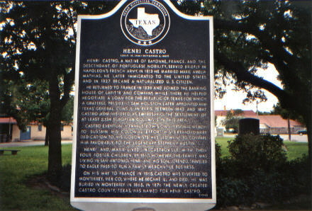
Henri Castro
(marker located at September Square, bordered by US
90, Alamo St., Lafayette St. & Fiorella St., Castroville)
Henri Castro, a native of Bayonne,
France, and the descendant of Portuguese nobility, served briefly in
Napoleon's French Army. In 1813 he married Marie Amelia Mathias. He
later immigrated to the United States and in 1827 became a
naturalized U.S. Citizen. He returned to France in 1838 and joined
the banking house of Lafitte and Company. While there he helped
negotiate a loan for the Republic of Texas for which a grateful
President Sam Houston later appointed him Texas' General Consul in
Paris. Between 1843 and 1847 Castro administered, as Empresario, the
settlement of at least 2,134 European colonists in this area. Castro
eventually exhausted his own personal wealth to sustain his colonial
effort. His extraordinary dedication to his colonists has led many
to compare him favorably to the legendary Stephen F. Austin. Henri
and Marie lived in Castroville with their four foster children. By
1860, however, the family was living in San Antonio. Henri and his
son, Lorrenzo, traveled to Eagle Pass to run a family mercantile
business. On his way to France in 1865, Castro was diverted to
Monterrey, Mexico, where he became ill and died. He was buried in
Monterrey in 1865. In 1876 the newly created Castro County, Texas,
was named for Henri Castro. (Marker - 1994) |
|
Historical Area Marker
(3.3 miles east of
Devine on 173)
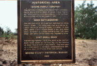
Moore Family Cemetery
One half mile northeast is the Moore Family
Cemetery. Daniel Boone Moore, father of famed Indian Fighter Lon Moore
and cousin to Daniel Boone is buried there. Moore settled on Hondo Creek
in 1852. (Although it has not been proved that he is a cousin to
Daniel Boone.)
Rock Battleground
One half mile south are large rock outcroppings along Chacon Creek. The
rocks were used as a refuge by Indian and settler during a number of
battles. In June 1862, Hondo Creek settlers fought a day long battle
there. A number of Indians, including the chief, were killed. One settler,
Nathan Davis, was wounded by arrow.
Fort Ewell Road
Intersecting Highway 173 at this point is the Old Fort Ewell Road,
which cut off from the old San Antonio de Bexar Road at present day
Natalia. The road went on a direct course to Fort Ewell, established in
1851, 20 miles down the Nueces River from Cotulla.
(Marker - 1985)
Thanks to Renee
Smelley for this contribution. |
|
Hondo
Spanish explorers passed this way
several times in the centuries preceding Anglo settlement of the
area. The original village that would become Hondo was situated on
"El Arroyo Hondo," named by the Spanish. Permanent settlers to the
area began arriving with Henri Castro in the 1840s. The Galveston,
Harrisburg and San Antonio (GH&SA) Railroad began to consider the
busy village on Hondo Creek for the location of a depot in the late
19th century. They ultimately chose 188 acres five miles west of the
town. The first deeds were executed in 1881. A post office for Hondo
City was approved in 1882. Knowing that the county seat might be
moved from Castroville to a more central location, the GH&SA donated
land for a courthouse in 1883. The county seat was relocated to
Hondo City in 1892. In the early 20th century the town, by then
known simply as Hondo, developed as a trade center and cotton
shipping point. Oil was discovered in the area in the 1920s. The
population grew steadily with commerce; by 1940 it reached 2,500.
The town's population exploded in 1942 when an Army Air Corps base
was built to the northwest. Hondo was incorporated that year and the
federal government provided educational funds and installed a sewage
system to accommodate the boom. At its peak Hondo had an estimated
population of 12,000. The base was closed in 1946, but continued to
operate as a civilian pilot training center through the 1950s. Hondo
grew steadily in the late 20th century. Its population in 1998 was
more than 8,000. The community continues to thrive. (Marker - 1999)
Incise on base: Dr. John and Mrs. Gail Meyer, J. A. Guedea Rios |
|
Hondo Methodist Church
(1006 16th St., Hondo)
Early Methodist settlers in this area
worshipped under a live oak tree on the banks of the Hondo Creek.
The Methodists organized as a church in 1857 and held services in a
log hut. A church/Masonic lodge was built on ten acres of land given
to the church in 1859. Circuit riding ministers held services once a
month. After the congregation moved to this site in 1890, newer
buildings replaced outgrown structures. The church maintains its
heritage of ministries for its members and a variety of community
missions. (Marker - 1997) |
|
Ihnken Family Cemetery
(Alsace Avenue, just east of Gentilz Street
intersection, Castroville)
Early Castroville colonist and Dutch
immigrant Marie Becker Ihnken was buried just north of this site in
1847 by her son, Gerhard. The German-born Gerhard married Marie
Jeanne Pichot on October 22, 1846. The Pichot family arrived on the
first of Henri Castro's ships. Though they originally intended to
return to France, the Pichot family remained in Texas after Marie
Jeanne's father, Jean Nicolas, died of complications after a
rattlesnake bite. Major civic leaders in early Castroville, the
Ihnkens were farmers who raised cattle and owned and operated a
sawmill, a store, and a fruit orchard on their vast lands.
Particularly remembered for his agricultural contributions, Gerhard
is said to have brought the first reaper and the first binder to the
Castroville area. One of the oldest cemeteries in Medina County, the
Ihnken family plot contains eight family members in marked graves;
several others are unknown. Marie Becker Ihnken is one of the few
older Castro colonists whose grave is still marked. A Freedman
employed by Gerhard Ihnken is said to be buried in the cemetery. To
avoid disturbing unmarked graves, the cemetery has been inactive
since 1950. (Marker - 1997) |
|
Judge Thomas L. Devine
(1820-1890)
(Southeast Corner of 132 and 173, Devine)
Born in Nova Scotia. Came to Texas in
1843. Became District Judge, 1851. On the powerful Public Safety
Committee of the Texas Secession Convention, 1861. Named with Samuel
A. Maverick and Philip N. Luckett to take possession of the federal
property in Texas. Backed by Col. Ben McCulloch and 1,200 minute
men, forced surrender of 3,000 troops with arms, ammunition,
supplies and $30,000 cash. Served throughout the Civil War as one of
two Confederate Judges in Texas. Tried cases of persons accused of
Union sympathies; dispositions of goods owned by Northern enemy; and
maritime disputes arising from the coastal blockade and shipwrecks.
In 1864 was made Special Commissioner to settle disputes among
foreign merchants handling cotton (South's only medium of trade for
vital supplies) across the Mexican boundary. At war's end, left with
other Texas leaders hoping to continue fight from Mexico. On his
return became only Southerner besides President Jefferson Davis to
be twice indicated for treason. Was pardoned in June 1867 by
President Andrew Johnson. On Texas Supreme Court and University of
Texas Board of Regents. This town named for him in 1882.
(Marker - 1964) |
|
Koch's, J.M. Hotel
(on
FM 1796 (Main Street), 1 block north of US 90, D'Hanis)
J. M. and Mary Ann Koch owned and
operated a hotel in D'Hanis beginning in 1898. They purchased the
land on this site in July 1902, and built this hotel in 1906.
Reportedly constructed by Chinese railroad laborers, it is built of
early bricks from the D'Hanis brick plant. In December 1914 the Koch
family sold the building, which continued as a hotel until 1920. The
Farmers Exchange of D'Hanis purchased it that year for use as a feed
store, adding a cotton scale to the east side of the structure. A
later owner operated it as a boarding house. A simple but elegant
early 20th century hotel with Late Victorian details, the edifice's
notable architectural features include its symmetrical plan,
three-bay façade with central door, paired round-arch windows,
2-story porch and corbelled brickwork on the parapet. (Recorded
Texas Historic Landmark, 2000) |
|
Landmark Inn
(intersection of US90 & Florence St., Castroville)
Built as a one-story home and store,
about 1844, by French settler Caesar Monad. Later became Vance Inn,
after top floor and bath house were added, to accommodate travelers.
Civil War bullets were made of lead lining peeled off a room of the
bath house, in 1860's. After 1927, Jordan T. Lawler and his sister,
Ruth Lawler, natives of New Orleans, La., owned and restored inn.
(Recorded Texas Historic Landmark, 1965) |
|
Landmark Inn Complex
(intersection of US90 & Florence St., Castroville)
The Landmark Inn Complex is a series of cut
limestone structures laid up with adobe-type mortar and covered with
white-washed lime plaster. The solid stone walls of the buildings
vary between eighteen and twenty-four inches thick.
The original structure built by Caesar Monad on
the Landmark Inn property was a one-story stone structure with
separate kitchen building. This structure forms the first floor of
the two-story hotel building. The Caesar Monad house and store,
built circa 1850, was considerably enlarged by John Vance about 1854
when he made the Monad house and store into a two-story building and
added a large, sixty- foot, one-story wing paralleling the Florella
Street line of the property.
The Vance Hotel and store building has lime
plaster finish on both exterior and interior walls. The hotel has
six chambers on the upper level reached by an exterior stairway
located in the inset double gallery on the south elevation. The
first floor has three chambers and the store is housed in the
sixty-foot long one-story wing. The double French-type doors which
open onto Florella Street have a simplified Greek Revival
entablature with a shallow pediment, crosses and a simple surround
molding.
The front of the hotel and the store wing are
almost flush with Florence and Florella streets. There is very
simple architectural detail throughout the building. The main
building has two end chimneys one is connected to a corner fireplace
in the northeast first floor chamber.
The two-story stone bath house has an exterior
stair and balcony. According to tradition, the upper room, which
served as a tank, was lined with lead. During the Civil War, this
lead was melted to furnish bullets for use by the Confederates.
The kitchen, slightly to the west of the hotel
building, is a simple one-story cut-stone structure with an end
chimney.
On the same property, southeast of the hotel, is a
one- and-a-half-story structure of plastered cut stone which John
Vance built to the house his family. The building has a raised
basement used as storerooms. There is little architectural detailing
on the residence. The building has a central hall plan with
identical entranceways at the front, or north, elevation, and the
south elevation. The entrance has single door with a low
five-light-wide transom above. Small pilasters with capitals
separate the three-light sidelights from the door.
The rear doorway, which opens onto a wooden
balcony, repeats the composition on the main doorway.
At the rear of the property, adjacent to the
Medina River, is a twostory cut stone structure which was
constructed by G. L Haas and Laurent Quintle about 1858. The
handsomely simple two-story stone structure has an underground mill
race from the Medina River. This mill which was operated by Haas and
Quintle and later by John Vance also furnished the city of
Castroville with its first electricity and power in 1927.
Landmark Inn, a famous and historic nineteenth
century hotel in a remarkable Alsacian, early Texas town, is located
at the east end of town, one-half block from the highway, near the
Medina River bridge.
The first structure erected on the property known
as Landmark Inn was a one-story stone edifice with a detached
kitchen, built by Caesar Monad (or Monod) several years after the
founding of Castroville. Monad, a French settler who became mayor of
Castroville in 1852, purchased lot 1 of Block 1, Range 3 from Henry
Castro in 1849 and lot 2 of the same block and range from Michele
Simon in 1850. The structure which he erected was used as both a
residence and a store.
In February, 1853, John Vance purchased lots 1 and
2, Block 1, Range 3 from Monad for $3,500. John Vance, born in New
York in 1819, first settled in Little Rock, Arkansas, along with his
brothers, James and William, and began a mercantile business. After
several years, the three brothers moved to San Antonio and opened a
general store on Alamo Plaza. John Vance withdrew from the
partnership and, after independently operating a store for a time in
San Antonio, he moved to Castroville.
Vance considerably enlarged the Monad house and
store by adding a second floor, a double gallery on the courtyard
facade, and outbuildings. The additions, using native stone,
followed the architectural style of the original house. The enlarged
structure served as both a store and a hotel. "Vance Hotel" as the
property was known for years, was an important stopping place for
travelers to and from Mexico. Part of the hotel's renown came from
an unusual feature for the time and place - a stone bath house,
located in the courtyard.
Vance also operated a gristmill. This was housed
in the two-story stone mill located behind the hotel property, to
the Medina River. The mill property had been sold to G. L. Haas and
Laurent Quintle by Henry Castro for $700. The dam, an underground
mill race channel and the mill were constructed by Haas and Quintle.
Sometime after 1858, Vance acquired the mill. This mill also
furnished Castroville with its first electricity and power in 1927.
In addition to the Vance Hotel, John Vance built a
one- and-a-half-story stone structure on a raised basement to the
rear of the hotel. This structure housed the Vance family on the
main floor and the basement was used as a warehouse.
John Vance was postmaster from July 1, 1867, to
June 30, 1878. The post office was located in the large first floor
room at the corner of Florence and Florella streets. Vance and his
descendants owned the property until 1899. John T. Lawler purchased
the property in 1925 and resided there until his death in 1970. The
Landmark Inn complex is now owned by Miss Ruth Lawler, John T.
Lawler's sister.
Recorded Texas Historic Landmark - 1965.
BIBLIOGRAPHY ON FILE IN THE NATIONAL REGISTER
|
|
Leinweber Building
(M Street on downtown Plaza, Highway 90, Hondo)
Built in 1907 for Ernest Roland
Leinweber (1869-1922), a prominent Hondo businessman, this
three-story commercial building was constructed by prolific South
Texas contractor Gus Birkner, who also participated in the
construction of the Texas State Capitol. Built with locally produced
brick, the structure features some influences of. Classical and
Romanesque styles of architecture. The Hondo landmark has housed a
variety of professional and commercial offices. (Recorded Texas
Historic Landmark, 1986) |
|
Louis Haller House
(Fiorella Street #1307, Castroville)
A native of France, 17-year-old Louis
Haller (d. 1920) came to Texas with his father in 1845. He was a
scout for the Texas Rangers and a wagoner during the Civil War. In
1871 he married Leonie Naegelin (d. 1918). They built this house
about 1877 for their growing family. The limestone structure is
similar in style to many pioneer homes in Castroville. The chimney
of the unusual corner fireplace angles through the wall and sits at
the peak of the roof over a window. (Recorded Texas Historic
Landmark, - 1978) |
|
Masonic Cemetery of Hondo
Valley Lodge No. 252, A.F. & A.M.
(From US 90, cross tracks & go about 3.7 miles east
from Avenue K, then about 1.7 miles north on local road)
In 1859, a decade after Medina County
was created, Freemasons and others in the New Fountain Settlement
built a 2-story stone church-lodge hall at this site. Hondo Valley
Lodge No. 252, A.F. & A.M., was chartered in 1860. The Masonic
Cemetery was opened here in 1864 when Junior Warden Rubin Smith was
killed by Indians. Masons and members of their families rest here in
22 graves. By an unexplained circumstance, Masonic emblem is upside
down on 2 headstones. Hondo Valley Lodge, demised in 1883, was
parent of Devine Lodge No. 590 and Hondo City Lodge No. 756, A.F. &
A.M. (Marker - 1973) |
|
Medina County Courthouse
(at intersection of Highway 16 & FM462, Courthouse
Square, Hondo)
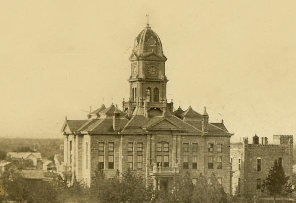
Medina County was founded in 1848
with Castroville as the County Seat. In 1892, as the result of an
election, the seat of county administration was relocated to Hondo
City (now Hondo). The commissioners court immediately ordered a
courthouse to be built at the new county seat. During the
administration of County Judge B. Brocks, a building contract was
let to the construction firm of Martin, Byrne & Johnson. Limestone
with a slightly yellowish cast was secured about six miles north of
town from the ranch of Joe Decker. Completed in 1893, the new
courthouse provided office space for the county judge, tax assessor,
treasurer, county attorney and district clerk, and featured a large
district courtroom on the second floor. Between 1939 and 1942,
changes to the 1893 courthouse were made, including the addition of
two two-story wings. Stone for the wings was secured again from
limestone deposits on the Recker Ranch. The classical revival
courthouse exhibits some influences of the Italianate style.
Prominent features include the rosticated stone walls, classical
portico over the entry way, a broken triangular pediment, and stone
hold molds with incised eastlake designs. (Recorded Texas Historic
Landmark, 1984)
Additional Notes: The original ornate clock tower was removed
and wing additions were added by the WPA (1938-1940), Architect,
Joseph Palle. |
|
Medina Dam
(on Dam Walkover in Mico)
Henri Castro, who colonized this area
in the 1840s, envisioned irrigated farms along the Medina River. The
project was delayed, however, until after the turn of the century,
when Dr. Fred Stark Pearson, an internationally known engineer,
persuaded British investors to finance construction of a dam at this
site. Completed in 1912, Medina Dam was hailed as the largest in
Texas and the fourth largest in the United States. Limestone
boulders from a nearby quarry added bulk to the massive concrete
structure. Four miles downstream, a small diversion dam conducted
water into a system of irrigation canals. Gravitational force
delivered the water to fields. The outbreak of World War I (1914)
disrupted ties with British investors. Seeking new capital, Dr.
Pearson and his wife left for England in 1915 on the "Lusitania" and
were killed when a German submarine torpedoed the ship. The
irrigation network created by Medina Dam brought new prosperity to
this region. Vegetables raised in irrigated fields became a valuable
crop. Water and electricity were made available to rural residents.
In 1925 voters established the Bexar-Medine-Atascosa Counties Water
Improvement District No. 1 to manage the project. (Marker - 1978)
Dr. Fred Stark Pearson created the Medina Irrigation
System as a private corporation with British financing in 1910. His
plan was to impound a large quantity of water which would be carried
south by a system of canals and used for irrigation where needed on
company lands.
Construction of the dam began in 1911. When
completed in 1912, its 292,000 cubic yards of concrete made it the
fourth largest in the United States and the largest in Texas. It
contains approximately 90% of the volume of concrete mass of the
Roosevelt Dam on the Salt River in Arizona.
The Medina Dam is 1580 feet along its top and
stands 164 feet above the Medina River bed. Its thickness ranges
from 128 feet at the base to 25 feet at the top. The total capacity
of the reservoir is over 250,000 acre-feet of water.
The excavation made for the foundation of the dam
was 105 feet wide at the base and extended from bluff to bluff.
Although solid rock was located 12 feet below the river bed in most
places, the alluvial deposits required excavation to a depth of 25
feet. Large holes were drilled and filled with concrete to anchor
the dam to the solid rock foundation.
Builders of the Medina Dam were fortunate in
having a large quarry nearby. Large limestone boulders, called
plums, were added to the concrete laid, thus economically increasing
the bulk of the dam. Due to the gravity type construction used in
the Medina Dam, it contained little reinforcing material; its
strength lies in its solid concrete mass.
Associated with the main dam, a diversion dam was
built four miles downstream to divert water into canals which
eventually lead to flumes and lateral ditches for irrigation. The
diversion dam is of solid concrete construction and measures 44 feet
wide at the base and 50 feet in height. It was built on a radius of
700 feet and is 440 feet in length. It is a massive weir structure
with a spillway at its center.
Because of the quality of construction, the dam,
the main canal, the flumes and in the diversion dam are in excellent
condition today. Minor repairs have been made, but these were
primarily to stop seepage of water through the limestone formation.
The entire system is in operation today, irrigating fields in Bexar,
Medina, and Atascosa counties of Texas.
The construction of the Medina Dam was the first
phase of a master plan by professional engineers to irrigate
agricultural land west of San Antonio, Texas. The dam was designed
to impound water from the Medina River watershed, to release it to
provide irrigation for farms in Medina, Bexar, and Atascosa
counties. The long range plan was to establish townsites, to lay out
farms and ranches, to sell land, and to supply water to farmers
commercially on a permanent basis. The Medina project is today
providing water for local farms.
The system as built included a main dam to impound
the water and a diversion dam four miles downstream to divert water
into the canals. These canals and flumes flowed by gravity to
laterals which provided water to individual farmers.
The excavation for the main canal and distribution
canals was conducted by private contractors. Work on the project
commenced November 1, 1911, and concluded in 1912. Canals and
ditches measured a total of 300 miles in length. In order to avoid
rough country, the main canal was routed beneath the Medina River
twice by means of inverse siphons which consist of pairs of concrete
pipes eight and seven feet in diameter. Collapsible wooden frames
and wooden panels were used as forms for the construction of the
siphon. One of the most striking structures of the canal are the
flumes. Originally there were eleven such flumes from 122 to 1520
feet long. All flumes were made of No. 180 Hess galvanized Toncan
steel semi-circular material.
Both the main dam and the diversion dam are
constructed of monolithic rubble masonry with large limestone
boulders embedded in the concrete. Both dams rest on excellent
limestone foundations. The main dam stands 164 feet above the river
bed with its foundation excavated to a depth of 12 feet and an
upstream cutoff toe extending 13 feet deeper. The upstream face is
vertical while the downstream face drops vertically 8 feet, then
curves downstream on tangent curved surfaces with radii of 80 and
230 feet to a plane surface near the base with a 66 to 100 slope.
From bluff to bluff the main dam measures 1580 feet with a thickness
of 25 feet at the top and 128 feet at the base. 13 feet above the
base is an inspection tunnel situated 23 feet behind the face of the
dam.
The diversion dam located four miles downstream
from the main dam, is an overflow or weir structure. Its purpose is
to divert the water released from the main dam into the head of the
main canal.
Upon completion the Medina Dam was the fourth
largest dam in the United States and the largest in Texas. The
massive bulk of the dam made it a significant engineering structure
and has allowed it to remain in use for over sixty years. Although
today it is operated by a local governmental body, the system
represents one of the earliest projects of its size in Texas to be
financed by private capital. For over half a century it has provided
a solid base for irrigated agriculture in the counties west of San
Antonio.
BIBLIOGRAPHY ON FILE IN THE NATIONAL REGISTER
|
|
Mission Valley
(City Park North on FM 462, Hondo)
Following Texas Emancipation in 1865,
many freed slaves remained in this area on their former masters'
farms. By 1869 blacks had organized a church and a school on the
north bank of Hondo Creek (about 2 mi. N). Beginning in 1876,
landowner L.L. White (d. 1889) sold small farm plats on the north
and south banks of Hondo Creek exclusively to blacks. White, an
abolitionist before the Civil War, was a native of Massachusetts and
settler in Henri Castro's colony. The community on the south bank
was named Mission Valley by Austin Grant, one of the first settlers.
Residents on both banks of Hondo Creek established common facilities
within walking distance of both settlements. Before 1881 their
church building housed both Methodist and Baptist congregations and
the school. Cottonwood Cemetery overlooks the creek, its oldest
tombstone dates 1886. Emancipation Oak was the site of Emancipation
Day pilgrimages on June 19. Many of the settlers and the Methodist
church moved to the new railroad town of Hondo (2 mi. SW) after
1881. The Baptist church moved to Hondo in 1904. Descendants of the
first settlers lived at Mission Valley until 1942, when a U.S. Army
air field was built here. The site was made a Hondo city park after
1948. (Marker - Texas Sesquicentennial 1836-1986) |
|
Mountain Valley
(on Medina Dam)
Established in 1854 by 16 families of
Mormons under the leadership of Lyman Wight (1796-1858). They
abandoned their homes and mills in 1858 as the result of Indian
depredations. Their lands are now beneath the waters of Medina Lake.
(Marker - Erected by the State of Texas - 1936) |
|
Moye
(Fronts Hwy 90 in Castroville on north side)
Named for the Rev. John Martin Moye,
founder (1762) of the Sisters of Divine Providence, religious order
that opened school in Castroville in 1868, and built first part of
this structure in 1873: first mother house of the order in the
United States. Occupants since 1900 have been Providence Industrial
School, St. Philip's Seminary, Refuge for Persecution Victims, and
several other endeavors. Repurchased 1939 by Sisters of Divine
Providence and used as military academy for boys. Now used as
Training Center for Religious Life. (Marker - 1972) |
|
New Fountain Methodist
Church
(New Fountain)
This region, known as Soldaten Kemp
(soldiers' camp) for its history as a rendezvous point for frontier
military patrols, freighters and others on the San Antonio Road, was
home to many German immigrants by the mid-19th century. The Rev.
John Schaper organized a Methodist congregation here in 1858 and a
church building was erected by 1860. Church members John and Aalke
Wiemers and Friedrich and Antje Muennink deeded land for a new
church building in 1871. Using native stone, pastor and stonemason
Jacob Bader built the new church with help from his parishioners.
For many years it was the community's only meeting hall. It was
enlarged in 1900-01 during the pastorate of the Rev. C. A. Lehmberg.
(Marker - 1975, 2000) |
|
Oefinger House
(2.7 miles north of Quihi on FM2676)
This well-preserved example of late
Victorian architecture was built in 1909 by Christian Oefinger
(1861-1950), son of early German immigrant Andreas Oefinger (b.
1819) and Ursula Nee Fuos, and his wife Marie (Schuele) (1872-1918).
A third bedroom, added in 1915, served as a boarding house for a
local schoolteacher. The house exhibits an asymmetrical plan with
crafted wood details and metal roof cresting. The house remained in
the Oefinger family for several generations. (Recorded Texas
Historic Landmark - 1995) |
|
Old Wurzbach Place
(from San Antonio, about 12 miles southwest on
Potranco Road, from Potranco Road take CR 381 north at one mile)
Built 1906 by H.F. Wurzbach, a
rancher and Medina County Commissioner, 1915-1916. He planned house,
featuring Colonial columns, banisters. His commissary, built 1915,
served neighbors and passing stage line. Ranch was bought by E.M.
Stevens Family, 1960. (Recorded Texas Historic Landmark, 1967) |
|
Ranch Home of Charles De
Montel
(only rooftop is visible from road - could not get in
tough with owner)
Frontiersman, soldier, and engineer,
came from Europe to Texas, 1838. Helped found Castroville and
organize Medina County. Served as county judge; Texas Ranger
Captain; and Navy Commander in Civil War (1861-65). Also a
confounder of Bandera. Wed Justine Pingenot in 1847. Built home
1848-50. (Marker - 1971) |
|
Robert Lee Bobbitt
(there is one each rest area (northbound &
southbound) From Natalia take I-35 about 1.5 miles northeast to rest
areas)
Robert Lee Bobbitt was born near
Hillsboro, Texas, the son of Joseph A. and Laura Duff Bobbitt. He
graduated from North Texas Normal College in 1911, and from the
University of Texas Law School in 1915. After opening a law practice
in Laredo, Bobbitt married Mary B. Westbrook on April 20, 1918,
while an officer in the 90th Infantry Division during World War I.
Bobbitt was elected to the Texas Legislature in 1923, served three
two-year terms, the last as Speaker of the House of Representatives,
and was appointed Attorney General in 1929. He returned to private
practice in San Antonio in 1931, and served on the Board of
Directors of the Texas College of Arts and Industries. In 1935, he
was selected as an Associate Justice of the San Antonio Court of
Civil Appeals, a post from which he resigned in 1937 to receive an
appointment as the Chairman of the Texas Highway Commission. During
Bobbitt's six-year term, the Texas Highway Department made great
strides toward a goal of a connected system of paved roads in the
state. In 1944, Bobbitt was a presidential elector, and, in 1958,
was appointed to his last public service post, as a member of the
Board of Regents of North Texas State College, his Alma Mater.
(Marker - 1974) |
|
Rothe-Rowe Ranch House
(inside Rose Ranch up at house - on drive. From
D'Hanis, about 3.2 miles north on FM1796)
On land bordering Fort Lincoln
(garrisoned by U.S. Army, 1849-53) and Woll Road (travel artery,
1840s-80s), owned after 1860 by Fritz Rothe and brothers. Louis
Rothe (1843-1921) built this native stone house in 1882. Successive
owners have had noted guests, including Gen. Jonathan Wainright,
U.S.A. (Recorded Texas Historic Landmark, 1972. Incised on base: Restored 1960s and preserved
by Mr. and Mrs. W. Earl Rowe. |
|
Schuehle-Saathoff House
(CR 365 to CR 4512, walk down road at Pichot Ranch
house on left)
Henry Schuehle immigrated from
Germany and purchased land near here. He owned this house, built in
1850. In 1900 the house was bought by S.H. Saathoff, whose family
came to Texas from Germany in 1846 and helped found Quihi. Saathoff
family members were active in public education, and lived here about
75 years. The house, a one and one half story cottage built with
native limestone, represents the vernacular tradition of 19th
century German settlers. (Recorded Texas Historic Landmark, 1996)
The well-preserved Saathoff House, located near Quihi
in rural Medina County, is a one-and-a-half story, vernacular,
limestone cottage constructed in the third quarter of the nineteenth
century. This simple and functional, yet charming, residence is a
good example of regional Germanic-Alsatian domestic architecture
characteristic of Medina County and Central Texas. The design of the
rectangular Alsatian-influenced Saathoff House, with five-bay
porched front, relatively low-pitched gable roof with end chimneys,
and native plastered limestone with lime-sand mortar construction,
differs from the characteristic Texas German style houses typical of
counties to the north which were settled by immigrants from central
Germany. Similar to other Eastern European pioneer Texas dwellings,
the architecture of the Saathoff House reflects the limitations of
the frontier environment. Its construction which was adapted to the
local building materials and climate of Texas, reflects the simple
and often rugged way of life German emigrants to Texas faced during
the second half of the nineteenth century. In addition to the native
limestone, local cypress was employed for wood framing and wood
finish work throughout the house, including structural members,
flooring, window frames and sash, and doors and door frames.
Approximately 26 feet wide by 41 feet long, the
rectangular structure contains a deep inset front porch with at
least five, and perhaps six, square wooden posts extending the
length of the five bay facade. The low-pitched gabled roof,
originally covered with cypress shingles, contains two chimneys with
articulated caps rising from the end masonry walls. A third chimney
is located in the southwest kitchen wall of the rear shed extension.
While the main portion of the gable roof is covered with corrugated
metal, the rear shed extension contains a standing-seam metal roof.
Typical of other substantially constructed vernacular German pioneer
dwellings, the stonework of the house is of exceptional quality and
reflects the mason's excellent craftsmanship and skill. Exterior
walls are constructed of hewn stones of various size; sealed
together with a plaster made of sand and lime which had been burned
from native limestone.
Fenestration of the Saathoff House is symmetrical
with single 6/6 rectangular openings with wooden trim appearing on
the front facade and northeast side. While the symmetrically
balanced front facade contains two single transomed doors flanked by
windows on either side, the northeast elevation displays two 6/6
windows and a smaller attic window reached by ladder. Historic
photographs reveal that first level windows were originally
shuttered and that the southeast side was also pierced by a smaller
attic opening.
With the exception of the enclosure of the rear
porch ca. 1920 and minor alterations made for the installation of
electricity, the structure's original interior has not been changed.
The original rectangular interior space is one room deep with three
approximately equal sized rooms, two of which contain simple
fireplaces with intact wooden mantels. When the rear shed porch was
enclosed, both a kitchen and small bedroom were formed and original
exterior openings, although somewhat altered, were left intact. All
ceilings throughout the house are constructed of beaded ceiling
boards and interior walls are plastered. Cypress boards were for
flooring in all the rooms.
Structural changes to the house, which have been
few and well-executed, have not adversely affected its historic or
architectural quality. Perhaps the major alteration of the original
structure was the enclosure of the rear south- east porch ca. 1920.
Modern aluminum screen doors and windows and siding have since been
added to this rear shed extension. According to historic
photographs, the structure's five-bay facades were retained,
although alterations were made in the size and location of some of
the original front and rear windows and doors. Some of the original
cypress shakes are still in place under the present tin roof. The
chimneys, although located in their original positions, were
originally exterior, instead of interior, chimneys. All of these
changes, however, are in keeping with the architectural integrity of
the home.
Outbuildings on the property originally included a
steep gable roofed wood frame barn situated to the southeast of the
house and a well at the southwest corner. Both structures, which
appear in historic photographs, no longer exist.
The physical condition of the house is fair, while
most of the original features of the interior and exterior have
remained untouched. Besides reinforcement of the southwest wall,
only minor repairs to the wood and stucco are currently needed.
Restoration plans, which include general maintenance and returning
the structure to its original physical condition, are currently
being executed by Mr. and Mrs. E. G. Hendrix, Jr., who purchased the
property in 1979. Some of their initial restoration work has
included the installation of a plumbing system and new roof. The
present owners reside in San Antonio, but intend to furnish the
house with antiques and occupy the house as a private residence and
vacation home.
The Saathoff House, built ca. 1870, is significant
for its historic associations with the early German settlement in
the vicinity of Quihi and the Saathoff family, whose members,
including Mimke H. Saathoff, Jr., Schweer H. Saathoff, and William
N. Saathoff, were instrumental in the establishment of the first
free public school system in Medina County. A substantial and rare
intact example of vernacular German-Alsatian stone architecture
common to this area, the structure has minor additions and few
alterations, and exhibits excellent craftsmanship in its stone
construction.
The Saathoff House. a typical nineteenth century
Alsatian-influenced German domestic stone structure, is located on
the south side of Quihi Creek in the community of Quihi,
approximately 8 miles east of Hondo. Specifically, the house is
situated in the north-west corner of the Nicholas Pingenot Survey
No. 9, Abstract 764, a grant of 320 acres which was surveyed on
October 11, 1846, for empresario Henry Castro, assignee of Pingenot.
Louis Huth, acting as agent for Castro, brought the first ten
families, predominantly German, to Quihi in 1846. Surveyed lots were
subsequently divided into farms of 640 and 320 acres for each
married and single man respectively.
There appears to be no evidence that Castro ever
resided on the Pingenot Survey which had passed, by the 1870s, to
members of the Schuehle, Schweers, and Saathoff families, all early
settlers of Medina County. The earliest history of the Saathoff
House has been difficult to document, but according to tradition it
was built about 1870 for Henry Schuehle. An 1871 subdivision map
shows a house belonging to Schuehle at the same location as the
Saathoff House, and structural and stylistic evidence supports post-
Civil War era construction. An interesting link with Medina County's
early history can be found beneath an oak tree south of the house;
it is the grave of a Mrs. Boehle, said to have been killed in an
Indian attack.
The Saathoff House was acquired shortly after 1900
by Schweer H. and William N. Saathoff, sons of Mimke, Jr., who had
purchased adjoining property some thirty years earlier. Born in
Hanover in 1839, Mimke Saathoff came to Texas with his family in
1846 as a member of Castro's Colony. His relatives were involved in
the founding of Quihi and instrumental in the formation of the
Lutheran Church in Medina County.
In addition to their early community involvement
in Quihi, the Saathoffs were closely associated with the
establishment of a public education system in Medina County. From
1873 to 1874 Mimke Saathoff, Jr., served as Medina County School
Trustee and in 1875 was elected President of the Board of Trustees
when a rock schoolhouse was built in Quihi. He donated the land for
the erection of one of the first public free schools in Quihi, while
his two sons eventually taught in the County school system. William
Saathoff, in particular, is remembered for his contributions as a
Medina County school superintendent, while Schweer H. recorded
Medina County's early history in a series of unpublished articles.
In 1944, after approximately forty-five years of
occupation by the Saathoff family, the house ceased to be occupied
regularly and began to serve as a hunting lodge and weekend home--a
function it continued to serve until 1979, when Mr. and Mrs. E. G.
Hendrix, Jr., of San Antonio purchased the property. During this
extended period few changes were made to the structure, which has
retained not only its architectural integrity, but its significance
as the residence of some of the earliest German pioneer families in
Medina County.
Architecturally, the house is similar in
construction and form to several other German stone pioneer
dwellings in the area which have severely deteriorated or been
altered beyond recognition. It is the only German house of this
period to survive in Quihi in such an unaltered, preserved state.
Despite the twentieth century rear enclosed addition to the house
and various minor alterations, the Saathoff House retains most of
its original fabric and character.
BIBLIOGRAPHY
Fletcher Davis, "M. Saathoff Came to Texas in
1846," Anvil Herald, Hondo, Texas, April 15, 1955.
" Quihi Settled 105 Year Ago," Anvil Herald,
Hondo, Texas, July 22, 1949.
Medina County, Texas. Board of School Directors.
Proceedings of Meetings Held During the Years 1871-1876. N.p.: n.p.,
n.d. Copy on file at the Barker Texas History Center, The University
of Texas at Austin.
Medina County, Texas. Deed Records, Assessor's
Abstracts.
Josiem Rothe, "Quihi, Born Amid the Turbulence of
Old Times, Is at Peace Today," San Antonio Express, January 13,
1935.
W.N. Saathoff, "Quihi Founded in 1844 by Henry
Castro," Anvil Herald, Hondo, Texas, July 22, 1949.
A. J. Sowell, Early Settlers and Indian Fighters
of Southwest Texas, New York, 1964.
Texas. General Land Office Bexar 3rd class, 4350.
United States. Texas. Medina County. 1860 Census.
Kathy Hendrix. Interviews with Mrs. Joe Arms,
daughter of S. H. Saathoff, granddaughter of Mimke Saathoff, Jr.,
1979; and with Martin Noonan, Medina County, Texas, 1979.
Peter Flagg Maxson. Interview with Kathy Hendrix,
Austin, 1 March 1982 |
|
Site of St. Dominic
Catholic Church & Cemetery
(from D'Hanis, 1 1/2 miles southeast off US90 in Old
D'Hanis)
Congregation formed in 1847 with
founding of D'Hanis Colony by settlers from Alsace, France. In 1853,
when town became a mission parish, limestone church was built, using
timber hauled by ox-wagon from Medina River. Sandstone extension was
built in 1868 upon arrival of first resident pastor but abandoned
after 1914 when new church was built in "New" D'Hanis (1 1/2 miles
west). Cemetery, dating from burial of child of colonists in 1847,
was used until 1893, when new cemetery was started following
diptheria epidemic. (Marker - 1972) |
|
Site of Fort Lincoln
(from D'Hanis about 2 miles northwest on FM1796, left
onto CR4204)
Est. by the United States Army July
7, 1849 as a link in a chain of posts extending from the Rio Grande
to the Red River. Named in honor of Capt. George Lincoln who fell at
Buena Vista Feb. 23, 1847. Abandoned July 20, 1852, after the
frontier line had advanced further west. (Marker - 1936) |
|
Site of the Homestead of
Henri Castro
(1107 Fiorella St., Castroville)
Henri Castro (1786-1861), a
naturalized American of French origin, befriended the Republic of
Texas and became interested in settling here. In 1842 he was given
authority to establish a colony of Europeans in Southwest Texas. He
succeeded in obtaining some land here on the Medina, from a 1766
grant made by Chares III of Spain. He recruited 485 families and 457
single men, mostly Alsatians. Using his personal wealth, he cared
for the colonists as though they were his children. In 1844 he had
the Castroville townsite platted, reserving as his homestead this
block next to the courthouse site, in the center of town. He erected
a stone dwelling and outbuildings, and planted an experimental
garden, to discover crops suited to the locality. Bringing his wife
Amelia (Mathias) and their four foster children from France, he
lived here permanently. As a moral obligation, he continued to
direct the state affairs for his colony, although it had
impoverished him. On the eve of a trip abroad when the Civil War was
beginning (1861), Castro and his wife deeded the homestead to their
adopted son, Lorenzo. Castro died at Monterrey, Mexico, soon
afterward, and was buried there. Lorenzo sold the homestead in 1872.
(Marker - 1978) |
|
Southern Pacific Depot of
Hondo
(2202 Eighteenth St., Hondo)
The first rail line reached this area
in 1881 and town lots were sold that year for Hondo City. The line
was built by the Galveston, Harrisburg and San Antonio Railway. It
connected with the Southern Pacific System building east from
California. The railroad was vital to the early growth of Hondo, but
rail traffic began to decline in the 1940s. The last passenger
train, pulled by engine No. 6, left the Hondo Station on June 8,
1958. The Southern Pacific Depot was moved to the present location
in 1970 from the original site, seventeen blocks east. (Marker -
1980) |
|
Spanish Exploration in
Medina County
(three miles north of Devine on 173)
By 1531 Spain ruled present Mexico,
Central America, the Caribbean, half of South America, and much of
the United States. The desire to claim new lands north of the Rio
Grande led to continuous Spanish expeditions through present Texas
during the 16th, 17th, and 18th Centuries. The expedition of Alvar
Nunez Cabeza de Vaca traveled through Texas between 1526 and 1537,
exploring and mapping the unknown territory. Later Spanish
expeditions, which established missions, presidios (forts), and
townships, included those led by Alonso de Leon; Father Manuel de la
Cruz; Father Juan LaRios and Fernando del Bosque; Domingo Teran de
los Rios; and Father Isidro de Espinosa. At least twenty Spanish
expeditions led by soldiers, missionaries, and settlers crossed
present Medina County before 1844. Detailed descriptions of the area
appear in the official accounts of many of the expeditions. Many of
the county's geographical features retain the names given them by
Spanish explorers of the 16th, 17th, and 18th Centuries. Spanish
names associated with early settlements, sites, rivers, and streams
serve as reminders of the rich Spanish heritage of the area now
known as Medina County. (Marker - 1989) |
|
St. John the Evangelist
Catholic Church
(2102 Avenue J, Hondo)
Constructed of seco brick in 1912,
this is the 2nd church structure to serve the Catholic community of
Hondo. Designed by the San Antonio architect Fred Bowen Gaeshen, it
was built by Alfred R. Wottlin during the pastorage of Rev. J.J.
Meyers. Used for all worship services until 1969, it was rededicated
as a parish hall in 1972. The brick detailing, round arches and
tripartite windows are typical features of the Romanesque Revival
style. (Recorded Texas Historic Landmark, 1972) |
|
St. Louis Catholic Church
(Angelo St., opposite Houston Square, Castroville)
Planned, according to tradition, by
the Rev. Peter Richard, pastor who came from Loire, France, 1868.
First (1847-51) resident pastor, the Most Rev. Claude Dubuis,
returned as Bishop of Texas to lay cornerstone on July 2, 1868.
Locally quarried limestone and labor of men of Parish went into the
construction. First Mass was celebrated in this church by Father
Richard on Aug. 25, 1870, Feast Day of St. Louis, Patron of the
Parish. (Recorded Texas Historic Landmark, 1970) |
|
St. Louis Cemetery
(1200 Jackson St. (on Hill), Castroville)
This cemetery has served the Parish
of St. Louis Catholic Church since the founding of Castroville in
1844. The original burial ground is outlined by the stone wall,
which was built in 1860. The earliest marked grave is that of
Katharina Haldy (d. 1849), who had migrated to Texas two years
earlier. Also buried here is Amelia Castro (d. 1871), the wife of
Henry Castro, who founded the town. The marble and granite altar was
dedicated in 1951. An annual prayer service and Mass is conducted
here each November 2, in honor of All Souls' Day. (Marker - 1980) |
|
St. Louis Church
(Angelo St., one block north from US90, Castroville)
Built by Alsatian settlers of Castro
Colony, in Republic of Texas. Dedicated by the Rt. Rev. John Odin,
C.M., first Catholic Bishop of Texas, on Nov. 9, 1846. Claude Dubuis,
1847 pastor, was later a Bishop of Texas. Here in 1868 Sisters of
Divine Providence opened their first permanent school in Texas.
First mother house of order in Texas was established in Castroville.
Marked on 100th Anniversary of founding The Sisters of Divine
Providence in Texas. (Recorded Texas Historic Landmark, 1966) |
|
St. Louis Day
(Angelo St., in front of St. Louis Catholic Church,
Castroville)
Since as early as 1847 residents of
Castroville have conducted a community holiday on or about the 25th
of August--the Catholic observacne of the Feast of St. Louis. Local
tradition recalls that early processions escorted clergy from the
priests' house adjacent to St. Louis Church, with clanging of anvils
and the blare of the community band. Through the years a picnic
became traditional on the church grounds following High Mass. Before
the festivities, men smoked sausage and pit-barbecued beef. Women
prepared potato salad, cabbage slaw, and desserts. An evening dance
in a local establishment ended the day-long celebration. The St.
Louis Society, founded in 1875, traditionally organized the event.
Since 1889 the celebration has raised funds for the benefit of the
Parish church and school. After the 1920s, the picnic and dance were
held at Wernette's Garden. That site (4 blocks NNW) was donated to
the parish and renamed Koenig Park in 1949. The dance pavilion there
was erected in 1953. The celebration is now held annually on the
Sunday nearest August 25. The procession begins at the church after
Mass, and winds through the city to Koenig Park for the picnic lunch
and evening dance. (Marker - Texas Sesquicentinnial 1836-1986) |
|
Stroud's Blacksmith Shop
(103 Herring St., Devine)
Joe Stroud (1877-1966) came here from
Bigfoot in 1903, and established a blacksmith shop on this site,
continuing in the craft learned from his father. Stroud soon became
known throughout the southwest for his branding irons, and had a
reputation as an expert farrier, once shodding all four feet of a
horse in nine minutes. He persisted in working in the shop until
shortly before his death. Although the business has expanded, the
original anvil still rings loud from the blows of Sherille Stroud,
who maintains the Stroud family tradition. (Marker - 1975) |
|
The Joseph Meyer
Homestead
(800th block, Lower LaCoste Rd, Castroville)
Joseph (1803-87) and Katherine (Koos)
Meyer, pioneers from Alsace, bought this 4-acre homestead in 1855.
Except for a roadway, it remains as platted by surveyor John James
for Henri Castro in 1844, and is the only undivided tract in
Castroville. The house is typically Alsatian in roof line and room
arrangement. The thick rock walls were plastered with lime from
Meyer's kiln near the Medina River. Meyer gave his land to a
daughter, Mrs. Leahr. Alex, Rosalie, and Fred Jungman, and the
Robert Gerloffs were later owners. Col. and Mrs. Irvin Keefer bought
the tract in 1960. (Marker - 1976) |
|
The Wiemers Oak
(Up 2676, right at CR451 to CR454 (second house on
left)
The land on which this live oak
stands was purchased by German migrant Johann Wiemers, who came here
in 1854. The Rev. John Schaper held services under the tree and
converted Johann and his wife Aalke to Methodism. They became
charter members of the new Fountain Methodist Church. The first
church building was erected near this site. This tree also shaded
the Wiemers and their neighbors as they met for reunions or used a
mule-drawn press in molasses making. The land was inherited by
Wiemers' descendants, who built a home near the ancient oak. (Marker
- 1977) |
|
Town of D'Hanis
(D'Hanis, 1 1/2 miles southeast of US90 in old
D'Hanis)
Established in 1847 by 29 families
under the leadership of Theodore Gentill, representing Henri Castro
(1781...1861), distinguished pioneer and colonizer of Texas who
introduced the early settlers of Medina County. Named in honor of
Guillaume (William) D'Hanis manager of the Colonization Society.
When the Southern Pacific Railroad missed the town, its citizens
moved to present D'Hanis. (Marker - Erected by The State of Texas -
1936) |
|
Town of Quihi
(at the dead end of CR4520, across from Bethlehem
Church on FM2676, Quihi)
Surveyed in October, 1844, by Henry
Castro, 1781-1861, distinguished pioneer and colonizer of Texas est.
in March,1845. By ten families in charge of Louis Huth, agent for
Castro. Many settlers were killed by Indians before 1860. (Marker
-Erected by the state of Texas, 1936) |
|
Vandenburg
(SR173 4 miles northeast of Hondo)
Located on the banks of Verde Creek
(Arroyo Verde), Vandenburg, founded in 1846, was one of the colonies
established by Empresario Henri Castro. Immigrants settled nearby
and began farming. They dug a trench eight feet wide by six feet
deep to protect them and keep their cattle nearby. Worship services
conducted by visiting ministers were held in homes or under an
arbor. Drought in 1847-49 caused crops to fail. Many settlers died
from cholera. Most families moved to other communities by the 1860s.
Two cemeteries are among the few physical remnants of Vandenburg.
(Marker - 1996) |
|
Yancey United Methodist
Church
(255 CR743, Yancey)
Completed in 1925, this church
building resulted from the combination of two neighboring Methodist
congregations. Circuit-riding Methodist preacher A. J. Potter began
holding services in a log schoolhouse south of Yancey in 1875. That
congregation eventually came to be known as Wilson Chapel Methodist
Episcopal Church, South, before it moved into the town of Yancey and
was renamed Yancey Methodist Church. North of town, the Yancey
Ebenezer Methodist Church, South, was founded in 1903-1904, with the
Rev. W. D. Wiemers as first preacher, to serve the German population
that lived in the area. In 1921, the two congregations were
combined, with the
Rev. F. W. Radetzky as first pastor. The church
building features classic Gothic detailing, such as the pointed
arches in the windows and the entryway. Gothic Revival was a popular
style for church designs at the time this building was constructed.
When detailed in wood rather than masonry, the style is known as
Carpenter Gothic. The square bell tower and gabled roof are other
prominent features of the building. An open-air tabernacle on the
property, once used for dinners on the ground, worship and outdoor
classes, was replaced with an education building in 1948. With its
history reaching back to the earliest evidence of Methodism in the
area, the Yancey United Methodist Church has played a strong role in
the cultural and religious history of the community. It continues to
serve the area with a variety of service and outreach ministries.
The historic church building remains a significant part of Yancey's
architectural heritage. (Recorded Texas Historic Landmark - 2001) |
|
Zuercher House
(1309 San Jacinto, Castroville)
The Jean Ulrich Zuercher house
was built in 1844 of batten board. It is on the National Register of
Historic Places and has a plaque attached to the front of the house.
The house had an outdoor kitchen, well, out buildings and a 40-acre
farm. Jean Ulrich (and wife Dorothe, daughter Maria Anna, her
daughter Hortense) was one of the 27 original colonists.
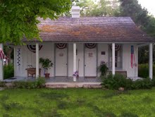 |
|
Zion Evangelical Lutheran
Church
(1106 Fiorella St., Castroville)
Many of the German settlers who
arrived here in the 1840s were Lutherans who kept their religious
traditions by meeting for worship in their homes. The Rev. Christian
Oefinger sailed from Bremen, Germany, arriving in Galveston. From
there he made his way to Castroville. Zion Evangelical Lutheran
Church was organized on January 29, 1852, with 12 charter members,
their families and other organizers, most from Castroville and
surrounding communities. Construction of the church building began
in 1853, with a loan for $400 secured from the general synod.
Congregants provided the rock, sand and timbers. A parsonage was
erected next to the church using the remaining stone. The church
prospered and became an important part of the Castroville community.
Pastor Oefinger held Castroville's first public school classes in
the Lutheran church building in 1857. The parsonage was replaced
with a frame building in 1922. The original stone church served the
congregation until 1939, when it was replaced by a new brick
building. An education annex was dedicated in 1949. The "Fuos Haus"
beside the church building was purchased in 1959 for use as a church
office. In 1960, the church purchased a building formerly known as
the George l. Haass Store. It was restored for use as a youth
building. The frame parsonage became a Sunday school building in
1996. Zion Evangelical Lutheran Church remains an active ministry
within the community, following the example set forth by the
members' ancestors throughout the church's history. (Marker - 2000) |
| Most of the above information came
from the Texas Historical Commission
Atlas |
|
TXGenWeb, Medina County - Historical Markers updated on 11/05/2013
Questions or problems
regarding this web site should be directed to the TXGenWeb coordinator for
Medina County. This page may not be reproduced
for profit or presentation by any other organization or persons. Files may
be printed or copied for personal use only. Copyright 2003-2013.
|